![]() ISSN 0798 1015
ISSN 0798 1015

![]() ISSN 0798 1015
ISSN 0798 1015
Vol. 39 (Number 16) Year 2018 • Page 37
Valentina Alekseevna BUDAROVA 1; Natalia Viktorovna CHEREZOVA 2; Alexey Viktorovich DUBROVSKIY 3; Natalia Grigorievna MARTYNOVA 4; Julia Dmitrievna MEDVEDEVA 5
Received: 20/12/2017 • Approved: 25/01/2018
ABSTRACT: The development of the economy and society in modern conditions is inextricably linked with the urgent problem of ensuring the sustainability of the development of the territories, one of the mandatory conditions of which is monitoring changes under the influence of natural and man-made factors. Mining is impossible without the use of land surface, as well as transport infrastructure, which realizes and accompanies in time and space the transportation of traditional geo-resources. In this regard, one of the most important rights of a subsoil user is his right to a land plot, in the depths of which and on the surface the extraction of geo-resources is carried out. |
RESUMO: O desenvolvimento da economia e da sociedade em condições modernas está indissociavelmente ligado ao problema urgente de garantir a sustentabilidade do desenvolvimento dos territórios, uma das condições obrigatórias das quais é monitorar mudanças sob a influência de fatores naturais e causados pelo homem. A mineração é impossível sem o uso da superfície terrestre, bem como a infra-estrutura de transporte, que realiza e acompanha no tempo e no espaço o transporte de geo-recursos tradicionais. A este respeito, um dos direitos mais importantes de um usuário do subsolo é seu direito a um terreno, nas profundezas e na superfície, a extração de recursos geográficos é realizada. |

The lasting value that society and the state have is land, it occupies a unique and key position in the social and economic life of society. Solving the issues of sustainability of the development of territories, including the transport infrastructure in its composition, has always been relevant for any state interested in developing its own economy, Through road and freight transport, transportation is carried out, including traditional geo-resources, as well as the main passenger and goods turnover, which directly affects the country's socio-economic development. This is especially important for the Russian Federation (RF), as for the largest country in the world.
As of 01.01.2017, the area of the Russian territory is 17 125 191 square meters. km, and the population - 146.8 million people. Thus, the actual issue is the design and development of a road network for communication between settlements and production zones of deposits, often distant from each other for significant distances. In addition, the transportation of cargo, including geo-resources, directly affects industrial production, construction industry, trade, agriculture, recreation and tourism both in the territory of individual regions and the economic situation of the country as a whole. At the same time, there is a stimulating state policy aimed at the development of remote prospective territories with high resource potential by subsoil users [1]. In this regard, it is necessary to create a developed transport infrastructure and the country's road network not only within the boundaries of settlements, but also outside it [2]
In connection with the annual increase in traffic and the increase in the carrying capacity and speed characteristics of road transport, the organization of roads with high speed and throughput capacity, as well as the organization of territories for the accumulation, storage, sorting and analysis of goods in the form of so-called logistics centers LC).
The purpose of this study is to develop ways to justify the choice of land plots with the use of remote sensing data (RS) and geoinformation systems (GIS) with the possibility of further development of the subsoil use territory from the creation of roadside facilities to the regional level. The proposed methodology is universal for all constituent entities of the Russian Federation, since it is based on an analysis of the regulatory framework of the Russian Federation regulating the organization of land management in Russia, and also covers the issues of the road sector. In addition, as part of the ongoing development of GIS capabilities for design and land management, not only in Russia but also in other developed countries, it is expected that the developed methodology will be useful to other states that have a large flow of transport and cargo and use the basics of geoinformation analysis of the territory for forecasting its integrated development.
So according to the data of Valiev V.Kh., Blazhenkova N.M. [3], for today roadside service in Russia is at a stage of becoming. In this regard, it is necessary to pay special attention to the analysis of the two existing effective and most promising roadside service systems in the world - European and North American. For example, today in Germany there are more than 3.8 thousand specialized parking areas for trucks, which is more than 20 times higher than the similar Russian indicator. And the total length of roads in Germany is about 260 thousand kilometers, with an average density of about 700 kilometers per thousand square kilometers of the country. In Russia, these figures are 1396 thousand kilometers, which is 5.4 times the value of the length of roads in Germany. A total of about 3,500 public catering facilities, a little more than 500 campsites and motels, and nearly 4,000 petrol stations (gas stations) have been opened on the federal Russian roads. In connection with such a backlog of transport infrastructure in Russia in comparison with European countries, the issue of development and design of roadside service facilities of various directions - from parking for rest and catering to specialized parking for trucks and filling stations becomes topical. In addition, there is a need to create a LC in the country, for understanding which should consider the problems and trends in the transport and distribution of commodity flows, appeared in the 60-90 years of the twentieth century in the United States (USA) and Europe. Such tendencies include:
- excessive congestion of roads, primarily in the cities and an increase in the volume of freight road transport;
- lack of warehouse space in the vicinity of large cities;
- lack of port capacities and the need to build additional cargo handling and storage facilities, both in the ports themselves and in the territories located within the country;
- initiatives on national railways, which allowed to reduce the market share of rail freight.
The above tendencies should be considered for the development of the logistics market, not only to participants, but also to authorities at various levels: from local to state. Since it is the authorities of many states that are interested in supporting small and medium-sized enterprises as much as in the need to solve social problems.
Currently roadside maintenance is not sufficiently developed not only in the Tyumen region, but also in Russia as a whole. The need for roadside services and facilities is conditioned not only by the satisfaction of the needs of the immediate participants of the movement, but also by the prospect of investing entrepreneurs in the development of the territory of subsoil use.
It should be noted that the extraction and subsequent transportation of geo-resources is regulated not only by the developed regulatory legal acts and regulations that control the use of land resources in the Far North, but also by new technological solutions ensuring the implementation of criteria for land use efficiency and minimizing the area mastered land [4].
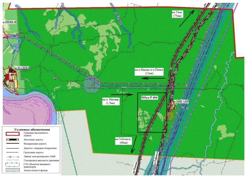
The research facility is located on the territory of Tobolsk district of the Tyumen region, the length of the federal highway P-404 is 952 km, including 156 km along the Tobolsk district. Within the borders of the Tobolsk district, the federal road starts at 154 km and stretches for 310 km. However, despite the importance of the existence of this route, including for the transportation of traditional geo-resources, it is necessary to note the shortcomings of the roadside infrastructure of the subsoil use region, they include:
- non-uniformity of location of roadside objects along the motorway;
-concrete range of services;
-the lack of a thoughtful concept and uniform standards of work, low level of service.
The number of existing road service facilities (ODS) of various types on the road is 132 with an average distance between them of 20 km, given that there are both oversaturated areas where there is too frequent contiguity to the road, and road sections in insufficient provided by one or another type of SLM, or not provided at all. Having familiarized with the list of existing SLMs, it can be noted that the largest number of facilities are located near the city of Tobolsk.
To select the location of the land for the purpose of further design of the SLM, a fragment of the federal road P-404 was identified in the territory of the Nadzyn rural settlement between 303 and 304 km. From 300 to 311 km the federal highway has a single SLM - a gas station. This site was transferred by the federal road agency Rosavtodor to the operational management of the federal state institution Uralupravtodor.
When choosing the land for the construction of SLM, it is necessary to take into account the conditions for ensuring road safety, construction and environmental standards.
A preliminary analysis of the study area revealed the following:
- the territory adjacent to the federal road refers to the lands of the forest fund;
- in 6 km there is a reserve of regional importance "Tobolsk mainland";
-The road connects the regional center with the Uvat and other oil fields;
- complete absence of any specialized parking for trucks;
-the nearest logistic center "Tobol-logistics" is located in the regional center of Tyumen;
- to the federal road are adjacent to local roads with hard surface: eastward to the village of Ingair (1.5 km), and in the western - to the villages of Nadca and Peña (11 km);
- The Sverdlovsk railway runs parallel to the federal highway, in the village of Ingair there is a station with the same name;
- there are no stopping points for bus passengers on this section of the route.
Based on this analysis, it can be assumed that the location of the object of roadside service on this site is promising, including for the development of the adjacent territory of subsoil use and for transportation of traditional geo-resources.
Figure 1 shows a fragment of the federal highway on the territory of the Nadzyn rural settlement.
Fig. 1
Fragment of the federal highway on the territory of the Nadzyn rural settlement
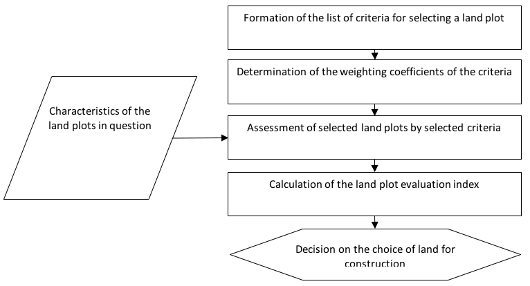
Esri space images and the official website of the Federal Service of State Registration, Cadastre and Cartography (Rosreestr) were used to familiarize themselves with the landscape of the territory. Currently, remote sensing data of the Earth, including space images, are becoming public: more and more organizations are using them in their activities, as this contributes to the efficiency and speed of solving a number of large-scale tasks. GIS-technologies are widely used, providing users of virtually all spheres of activity with colossal opportunities for analyzing spatial data and creating cartographic materials [5]. In order to justify the choice of land for the design of roadside service facilities, including when implementing and developing the transport of traditional geo-resources, it is advisable to follow the algorithm for comparative analysis of land plot criteria (Figure 2).
Fig. 2
Algorithm of comparative analysis of land plots for location of roadside service objects
When choosing a site for the construction of roadside facilities, it is necessary to take into account the safety standards for road traffic, construction and environmental protection, as well as:
- The category of road, the size of travel, traffic;
- the possibility of finding a roadside service on the side of the federal highway;
- features of the terrain, climatic characteristics of the area;
- the possibility of supplying engineering infrastructures;
- prospects for development of the adjacent territory;
- the need to create contiguity to the road.
The order of issuance of permits for the placement of service facilities and utilities in the right-of-way and roadside areas of public roads of federal significance includes procedures for selecting a land plot, agreeing on boundaries, preparing project documentation, obtaining a building permit, erecting an object and obtaining permission to enter object in operation.
The preparation of project documentation is closely related to the organization and conduct of cadastral work on the territory of the land plot included in the list of cadastral engineer services. It should be noted that the application of GIS databases in the field of cartographic-geodetic and cadastral activities of the cadastral engineer allows timely obtaining accurate, reliable and up-to-date data [6].
The coordination of the design documentation is carried out only after preliminary consideration of the document in Rosavtodor. To send documents to Rosavtodor, it is necessary to submit for technical approval in four copies the technical plan of the site with the object put on it and the drawings of this object submitted by the applicant on the scale:
-1: 500 in the design of roadside infrastructure facilities within the allotment and roadside lanes of federal highways;
-1: 1000 when placing engineering communications along highways [7].
If Rosavtodor receives a positive preliminary approval, the Federal State Institution sends a task for the development of a working project, with a negative response - a refusal to locate the facility.
According to [8], "the road includes land plots within the boundaries of the right-of-way and the structural elements located on or under them (roadway, road surface and the like) and road structures, which are its technological part, protective road structures, artificial road facilities, facilities for road construction. In this regard, objects of roadside service and maintenance should be located within the boundaries of the roadway ".
At the same time, the "road right-of-way" refers to land plots, regardless of the land category, designed to accommodate the structural elements of the highway, road structures and on which the road service facilities are located "[9].
Within the roadside lanes of highways of federal importance, a special regime for the use of land plots is established in order to ensure road safety requirements, as well as normal conditions for the maintenance of such roads [10].
Depending on the class and category of highways of federal significance, the width of each roadside strip is established from the border of the right-of-way for such highways within the range of 50 to 150 m.
SLMs include buildings, structures, structures, other facilities intended for servicing road users along the way (including gas stations, bus stations, bus stations, hotels, camping sites, motels, public catering points, service stations, similar facilities, and also necessary for their functioning places of rest and parking of vehicles) [11]. Table 1 clearly shows the classes and categories of the road, the types of ODS, the maximum distance to be regulated between these objects [12-14].
Table 1
Minimally necessary requirements for the security of motor roads ODS
Class, road category |
Type of road service facilities |
Distance, km |
Motorway (IA) High-speed road (IB) |
Motel (camping) |
250 |
Non-speed road (IB) |
1. Catering station |
100 |
2. Gas station (washing and trading enterprise) |
100 |
|
3. Service station |
100 |
|
4. Rest area |
50 |
|
Non-speed road (II), (III) |
1. Catering station |
100 |
2. Gas station (washing and trading enterprise) |
100 |
|
3. Service station |
100 |
|
4. Rest area |
50 |
|
Non-speed road (IV) |
1. Catering station |
150 |
2. Gas station (and trading enterprise) |
150 |
|
3. Service station |
150 |
|
4. Rest area |
75 |
|
Road (V) |
1. Catering station |
300 |
2. Gas station (and trading enterprise) |
300 |
The placement and size of the SLM depend on the intensity and composition of the movement; degree of economic development of the area of the road; travel zones; the average speed of movement on the route, the nature of the functions of structures, their attractiveness, therefore, profitability.
For acquaintance with the landscape of the territory under study, ERS data are widely used in practice. Based on the integration of web technologies and GIS, such a segment of geoinformatics, as geoinformation online services, develops and geoportals [15, p. 169]. An example of a publicly available geo-information online service is the Public Cadastre Map, which is placed on the official website of the Federal Service for State Registration, Cadastre and Cartography (Rosreestr) [16].
Information support for the real estate cadastre in Russia is realized through various means of automation of data flows and is formed in the form of databases and registers. Similarly, foreign cadastre information systems are provided, for example, the Joint Information System (JIS) (Croatia), which acts as a unique land cadastre and cadastral information systems [17].
The implementation of the software module ensures the high quality of document management, including the electronic interaction of specialists with Rosreestr, which is the most significant for the adoption of new laws and regulations [18, p. 3-11].
In addition, the process of using electronic public services is more convenient to implement based on the creation of a single personal user's cabinet, which will lead to an increase in the proportion of citizens receiving services electronically [19-21], with the experience of countries with highly developed real estate registration and registration systems protection of registration data [22-24].
It should be noted that modern GIS are effective in all areas where the accounting and management of the territory, including the fields and objects located on it, is carried out. These are practically all directions of the activity of the management bodies and administrations: transport, engineering communications, business development, emergency management, law enforcement and security, land and real estate management, demography, health care, ecology, etc. [25-26]
Scientists [27-34] estimated that most of the information (in different sources, values from 60% to 90% occur), which a person encounters in his life, has a territorial reference. Therefore, GIS can be used practically in any sphere of human labor activity.
Conceptual design solutions for improving the use of the information system data comply with international and Russian standards [35-37]. Thus, GIS is regulated by a large number of regulatory documents.
Figure 3 shows a fragment of a space image of 303 km of the federal road. The study of a fragment of the federal highway allows us to distinguish two areas with distinct forest cover, as evidenced by light areas (grassy planking) among dark areas of thickly sprouted trees. When visual interpretation of the image in these areas, the heads of lonely standing and standing in small groups (4-7 trunks) of trees. One of the sites is proposed to be located at the intersection of a local road to 304 km of the federal highway. The second section is proposed to be located on 303 km of the federal road on the left. Table 2 shows the indicators for analyzing the choice of land for the purpose of building an SLM, including in the organization and development of transportation of traditional geo-resources.
Fig. 3
Space image of the federal road section
-----
Table 2
Comparative characteristics of the selected areas
Index |
The plot №1 |
The plot №2 |
Location |
304 km, at the intersection of roads, in the border of the roadside strip |
303 km, the nearest junction / intersection of roads in more than 1.5 km, in the border of the roadside strip |
Vegetative cover |
More than 75% |
Less than 50% |
Land area, hectare |
1 |
1 |
Land category |
Forest lands |
Forest lands |
Type of ownership |
State property |
State property |
Proximity of transmission lines |
Direct proximity to 10kV transmission lines |
The distance to the nearest power line and communication lines is 1.5 km |
Possibility of gasification |
Yes |
Yes |
Proximity of water bodies |
3,5 km from the Big Ingair river |
4,5 km from the Big Ingair river |
Possibility of flooding |
No |
No |
Proximity to human settlements |
The regional center is 66 km away. 11 km from the villages of Nizhne Aremzane, Nadca, Peña and 1.5 km to Ingair village |
The regional center is 65 km away. 12 km from the villages of Nizhne Aremzane, Nadca, Peña and 1.5 km to Ingair village |
Specially Protected Natural Territories |
4 km from the regional reserve «Tobolsk mainland» |
5 km from the regional reserve «Tobolsk mainland» |
Based on the data in Table 2, it can be seen that both sections are located approximately one distance from the district center, while there is no possibility of flooding in the territory of the two options, i.e. the probability of emergencies is excluded. Both plots are state-owned, which greatly simplifies the construction of a SLM in the territory.
The planned area of the land plot will be up to 1 hectare, which will allow it to be located within the borders of the roadside strip. Thus, after evaluating the possibilities of the two sites, the option of placing the SLM in the territory of the land plot was considered. 2. The selected site enters the roadside and will be adjacent to the federal road P-404, which belongs to the second category and has two lanes with an average traffic of 8662 passing cars per day. The road has a roadway of 7.5 m, on both sides of the roadway the roadside is 3.75 m wide, the roadway and the roadside make up an earthen canal 15 m wide. On both sides of the roadbed there is a 25 m stretch to one side. The roadside strip is 100 m on each side after the right-of-way.
There is a possibility of gradual development of the land plot, i.е. the priority of the construction of roadside service facilities to attract investors.
In the long term, the project for the organization of a land plot and placement of roadside service facilities (ODS) on it can be developed in computer-aided design or GIS.
In this paper, the sequence of actions for justifying the choice of a land plot is presented. The advantage of this study is the procedure for justifying the choice of land - taking into account the terrain, terrain, infrastructure of the territory for the future object of roadside service.
Usually the risks of such projects are related to the insufficient flow of clients and their solvency. However, in the section of the federal highway Tyumen-Khanty-Mansiysk at 303 km, the lack of high-quality roadside service, high business activity and incomes of the population created favorable conditions for the deployment of roadside service, and the size of the land plot and the availability of a number of railways and available communications make it possible to use this territory for the location of the LC or the branch "Tobol-logistics".
The object of the research was a land plot allocated for the construction of a roadside service facility on the territory of subsoil use. The advantage of this study is:
-complete study of information on land plots and transport infrastructure of the territory of extraction of geo-resources;
-analysis of the received information using remote sensing data and GIS technologies;
- presentation of the algorithm for comparative analysis of land plots;
- development of criteria for assessing the choice of land plots, taking into account the specifics of the construction of the planned facility;
- justification of the choice of land plots with the help of GIS, for the creation of roadside facilities for servicing the transport infrastructure of the subsoil use territory, taking into account the conditions of the terrain, the relief, with the possibility of its further development to a regional level LC.
The obtained results of studies on the justification of the choice of the land plot made it possible to draw conclusions and give the first recommendations on the organization and development of the territory of subsoil use and transportation of traditional geo-resources in the territory of the Tyumen region.
Milyaev D.V., Savelyeva A.D. (2017) Prospective targets of geological exploration in the Siberian platform and criteria of their feasibility. Georesursy = Georesources. V. 19. No. 2. Pp. 88-96.
Tsybulsky A.I. (2016) Formation of a rational network objects of car service in the territory of inhabited points // Transport: nauka, tekhnika, upravlenie. - Transport: science, technology, management. M.: Izd-vo Vserossiyskiy institut nauchnoy i tekhnicheskoy informatsii RAN. No 7. – p. 59-62.
Valiev V.Kh., Blazhenkova N.M. (2015) Strategic view on the development of roadside service in the regions of Russia. Sovremennye problemy nauki i obrazovaniya – Modern problems of science and education. Available at: https://www.science-education.ru/ru/article/view?id=19684;
Dubrovsky A.V., Kustysheva I.N. (2017) Methodical and technological support of efficient land managment in hydrocarbon extraction considering regional features of the Far North // Vestnik SGUGiT [Vestnik of SSUGT]. 3 (35). – p. 128-139.
Budarova V.A., Medvedeva Y.D. (2017) Integration of GIS-technologies and remote sensing data for the analysis of rational land use // Geinformatsionnye tekhnologii v reshenii zadach ratsional'nogo prirodopol'zovaniya: Materialy III Vserossiyskoy nauchno-prakticheskoy konferentsii / AU «Yugorskiy NII informatsionnykh technology». – Khanty-Mansiysk. – p.6-9.
Martynova N.G. (2017) Development of a model for electronic document management in the performance of cadastral work: the author's abstract. dis. to the soisk. scientific degree of cand. tech. sciences. – Tyumen. - 24 p.
Ministry of Transport of the Russian Federation Federal Road Agency. Available at: https: //rosavtodor.ru/;
Resolution of the Government of the Russian Federation No. 848 of December 5, 2001 «On the Federal Target Program Development of the Transport System of Russia (2010-2020)» Available at: http://www.consultant.ru/;
Decree of the President of the Russian Federation No. 727 June 27, 1998 «On roadside lanes of federal highways of general use». Available at: http://www.consultant.ru/;
Federal Law No. 257-FZ of November 08, 2007. «About motor roads and road activities in the Russian Federation». Available at: http://www.consultant.ru/;
Order of the Ministry of Transport of the Russian Federation of January 13, 2010. No.4 «On the establishment and use of roadside lanes of motor roads of federal significance» Available at: http://www.consultant.ru/;
State Standart 52398-2005. Classification of highways. Basic parameters and requirements. Moscow, Standartinform Publ., 2006. 7 p. ГОСТ;
SNiP 2.05.02-85 Highways. Building regulations;
State Standart 33062-2014. Automobile roads of general use. Requirements for placement of road and roadside service objects. Moscow, Standartinform Publ., 2015. 24 p. ГОСТ;
Budarova V.A., Medvedeva Y.D., Cherdantseva N.G. (2016) Opportunity of creating geoinformational resource for the purposes of land monitoring on the territory of south Tyumenskaja oblast’ // Vestnik SGUGiT [Vestnik of SSUGT], 2 (34), 169-183;
The Federal Service for State Registration, Cadastre and Cartography – Rosreestr – Available at: https://rosreestr.ru/site
Husak, M. Joint Information System (JIS) as Unique Land Register and Cadastral Information Systems. Available at: https://www.researchgate.net/
Karpik A.P., Vetoshkin D.N., Arkhipenko O.P. (2012) Analysis of the current state of the state real estate cadastre in Russia. Interexpo GEO-Siberia-2012. VIII Intern. sci. congress. - Novosibirsk: SSGA. - P. 3-11.
Bahaaldine, Azarmi. Scalable Big Data Architecture. A practitioners guide to choosing relevant Big Data architecture. – Apress, 2016. – 200 p.
Enemark, S. Updating digital cadastral maps – The Danish experience // FIG-congress, Brighton 1998. Available at: http://www.fig.net/
Ronchi A. M. E-Culture. – New York: Springer–Verlag, LLC. – 2009. – p. 455.
Liegenschaftskatasters. Available at: http://www.landesvermessung.sachsen.de/.
Nichols, S. E. Land Registration: managing information for land administration / S. E. Nichols // Department of Geodesy and Geomatics Engeneering University of New Brunswick. – 1993. – 198.
Buscema M. The Neural Vision of a Compatative City: an Exploration on the Urban Winning Assets in the European Context. — Simeon-Centro Ricerche di Scienze della Communicazione. Viale di Val Fiorita, Roma, 1996. — 24 p.
Cartwright W., Peterson M. P., Gartner, G. Multimedia Cartography. – 2nd ed. – Berlin: Springer-Verlag, 2007. – p. 530.
Maiellaro N., Varasano A. One-Page Multimedia Interactive Map // ISPRS Int. J. GeoInf. – № 6 (2). – 2017. – P. 34–40.
Clarce К.C. Geographic information systems: definitions and prospects. — Bull. Geogr. and Map Div. Spec. Libr. Assoc., 1985. — № 142. - P. 12 —17.
Computer software for spatial data handling. International Geographical Union: Commission on Geographical Data Sensing and Processing. — Ottawa; Ontario, 1981. — Vol. 1: Full geographic information systems. — P. 136.
Dollfus O. Chaos bornes et monde actuel // Espace geogr., 1990, №4. – P. 302-308.
Environmental Data Report. Prepared for UNEP. — London: UK, Basil Blackwell, 1987.
Grafarend, Erik W. Map Projections [Text] / Erik W. Grafarend, Friedrich W. Krumm // Cartographic Information Systems Springer, 2006. – 731 р.
Herrington, Jack D. Five XML dos and five don'ts that you need to know How to use XML the right way 07 December 2010. Available at: https://www.ibm.com/.
Bugayevskiy M., Snyder J. P., Map Projections: A Reference Manual. – London: Taylor & Francis, 1995: http://www.worldcat.org/oclc/31737484.
Komissarov A.V. (2015). Theory and technology of laser scanning for spatial modeling territories. Extended abstract of Doctor’s thesis. Novosibirsk [in Russian]
ISO/TS 19139. Geographic information – Metadata – XML schema implementation;
State Standart 52155-2003. Federal, regional, municipal geographical information systems. General technical requirements. Moscow, Standartinform Publ., 2004. 12 p. ГОСТ;
State Standart 52438-2005. Geographic information systems. Terms and Definitions. Moscow, Standartinform Publ., 2006. 12 p. ГОСТ.
1. Ph. D., Tyumen Industrial University, 625000, Russia, Tyumen, 38, Volodarskogo St.. e-mail: budarova@bk.ru
2. Ph. D., Tyumen Industrial University, 625000, Russia, Tyumen, 38, Volodarskogo St.. e-mail: tigr_bn@mail.ru
3. Ph. D., Siberia State University of geosystems and technologies, 630108, Russia Novosibirsk, 10, Plakhotnogo St., e-mail: avd5@mail.ru
4. Assistant, Tyumen Industrial University, 625000, Russia, Tyumen, 38, Volodarskogo St. e-mail: natali.cherdanceva@mail.ru
5. Postgraduate, Tyumen Industrial University, 625000, Russia, Tyumen, 38, Volodarskogo St. e-mail: yul.medwedewa2013@yandex.ru