![]() ISSN 0798 1015
ISSN 0798 1015

![]() ISSN 0798 1015
ISSN 0798 1015
Vol. 39 (Number 14) Year 2018 • Page 22
Tamara Vladislavovna SIMAKOVA 1; Leonid Nikolaevich SKIPIN 2; Elena Pavlovna EVTUSHKOVA 3; Anton Vasilievich SIMAKOV 4; Ekaterina Alekseevna Pashnina 5; Anna Aleksandrovna MATVEEVA 6; Anna Anatolievna YURLOVA 7
Received: 08/12/2017 • Approved: 28/01/2018
ABSTRACT: The article presents the current state of reclaimed land in Tyumen region, scientific and methodical development approach to the implementation of elements of ecological mapping of the territory and the establishment of areas of appropriate extent of condition and use of land for their rational organization, conservation, development and restoration of natural resource potential. The modeling of the territory of Tarmanskiy wetland massif of sustainable development on the basis of the analysis, assessment and forecast, obtained a territorial model of sustainable development in the study area, was used in the process of research. The recommendations aimed at rational use and protection of land resources were developed based on the research findings. |
RESUMEN: El artículo presenta el estado actual de la tierra recuperada de la región de Tyumen, el desarrollo del enfoque científico y metodológico para la implementación de elementos de mapeo ecológico del territorio y el establecimiento de zonas con el grado apropiado de estado y el uso de la tierra para su eficiente organización, la conservación, el desarrollo y la restauración del potencial de recursos naturales. El estudio utilizó área de modelado Tarmanskogo pantano desarrollo sostenible sobre la base del análisis, evaluación y pronóstico del modelo territorial resultante del desarrollo sostenible de la zona de estudio. Sobre la base de las conclusiones de la encuesta y las recomendaciones dirigidas al uso racional y la protección de los recursos de la tierra. |

Rational land use is an important factor in the formation of a stable (sustainable) land use of an administrative area, as well as an element of taxation, as the right approach to the organization of land use, it is possible to oblige the tenant of land to develop derelict land treatment and improvement of already used lands, it will increase the stability of revenues to budgets of all levels (Simakova, Skipin, 2015; Simakova, Podkovirova, Oleinik, 2015).
One of the main mechanisms of regulation of the land relations is the improvement and the introduction of system of state land monitoring (Starovoitova, Simakova, 2017; Varlamov, 2009).
The relevance of the work lies in the fact that the monitoring of reclaimed land is the main tool that allows using the land rationally; this information is the basis of the land cadastre and allows managing land resources effectively.
The aim of this work lies in the establishment of favorability of Tarmanskiy wetland massif in Tyumen region on the basis of the analysis of the use of reclaimed land.
The Russian Federation is among the richest in water resources countries in the world. Part of the water complex is an ameliorative complex. Currently, a significant portion of reclaimed land (over 3.5 million hectares) is in poor condition. On the basis of the inventory of reclaimed land, it turns out, 58.4 percent are in state ownership of the Russian Federation and 34.7 per cent are ownerless out of the total volume of drainage facilities and systems. The problem of development of ameliorative complex is an intersectoral and an inter-ministerial problem.
State monitoring of reclaimed land is an integral part of the state monitoring of land and represents a system of observations of the condition of reclaimed land. On the basis of these observations, it is possible to reveale changes in the status of reclaimed land and to provide an assessment of such changes (Comissarov, 2011; Damdin, 2012; Shchedrin., Balakay, 2010).
It is necessary to carry out a complex of measures on optimization of their hydrological and ameliorative status to improve the efficiency of use of drained land and reduce the area with unsatisfactory condition. The authors proposed introduction of regional systems of geoinformation systems of monitoring of drained land with the display environment in real time in order to improve monitoring of reclaimed land (Forest code of the Russian Federation, 2016; Land code of the Russian Federation, 2017; Land reclamation, 2016).
The object of research is Tarmanskiy wetland massif of Tyumen region.
The wetlands of Tyumen region is presented in large arrays - from hundreds to tens of thousands of hectares. In the South the wetlands are almost exclusively lowland, transitional and raised wetlands appear North of Tyumen, then the zone of raised wetlands with individual low-lying spots, including the valleys of rivers, begins North of Tobolsk.
The land area under wetlands in Tyumen region is 4609,1 thousand hectares. The main areas of wetlands occur in forest land, agricultural land, land of water Fund and reserve land. In the course of conducting monitoring of lands in Tyumen region quantitative indicators of the area of wetlands had not changed in comparison with 2015. As compared with to 2010 the area of wetlands in the region decreased by 0.1 thousand hectares.
There are 2558 peat deposits in Tyumen region, 342 of them have explored field.
The wetlands are used as receiving waters for waste (drainage) water. According to the state water register the provision of wetlands in use on the basis of contracts of water use or decisions on granting of water object in use has been implemented in the Tyumen region 9 water users, the volume of waste (drainage) water is 1074,06 thousand cubic meters (Telitsin, 2002).
Tarmanskiy wetland massif is a complex natural formation, it refers to the lowland type. Actually wetlands occupy only 55% of the area, one third is covered by forests, many meadows suitable for hay and pasture.
The massif stretches along the Tura from West to East to 136 km. The width of the wetland massif is in different places from 7 to 40 km and the total area is of 124 hectares, according to physico-geographical differentiation refers to portage and Northern forest-steppe, according to wetlands zoning the massif refers to the area slightly convex autotrophic gipnoviy wetlands, the dominant group of wetland landscapes of grass and grass-moss, the type of water supply mixed (Water code, 2016; Pashnina, Simakova, 2017).
The subject of this work are the methods used for monitoring of reclaimed land, allowing to establish the degree of favorability of the study area.
The basis of our research is based on the system of monitoring of lands, proposed by Y. A. Izrael, which includes the main activities:
The analysis of observation results was conducted using the method of decoding, using manual interpretation of aerial photographs in surveying and updating of plans of scales 1:2000 and 1:5000.
The various degradation processes or improvement of wetland systems were identified as a result of the evaluation of the actual status of wetlands. On this basis, the forecast environmental and economic condition was done, using the following approaches: historical, comprehensive and systematic structural.
The prediction of ecological status was made on the basis of information about the development of degradation processes. Economic forecast is a calculation of losses from the development of degradation processes and loss of biological products.
To assess the favorability of the territory according to the monitoring results, used cluster analysis and developed a rating scale with the following clusters:
I – a zone of favorable situation includes the low degree of zakustarivanie (shifs from grassland to shrub), afforestation and waterlogging, hayfields and arable land.
II – a zone of relatively favorable situation are the average degree of zakustarivanie (shifs from grassland to shrub), afforestation and waterlogging.
III – a zone of unfavorable situation includes a strong degree of zakustarivanie (shifs from grassland to shrub), afforestation and waterlogging.
IV – a zone of particularly unfavorable situation includes areas with strong and weak degree of overgrowing and waterlogging or average degree of these processes.
To study we chose the area of the massif, located in Nizhnetavdinskiy and Tyumen areas. The total land area is 670 square kilometers. The paper presents the comparison of the item as of 1984 and 2015.
As of 1984, the area of wetlands was 183 square kilometers, 55 square kilometers of lakes. The main difference from the modern state is the presence of active and abandoned peat. Agricultural lands are represented only by hayfields. In the survey area there are all degrees of afforestation and bushed massifs, which are confined to a low degree of zakustarivanie (shifs from grassland to shrub) of 110 square kilometers. The presence on the area only this degree is distinctive in comparison with 2015.
The analysis of Tarmanskiy wetland massif showed that as of 1984, the low degree of waterlogging is seen only in the 36 square kilometers, a strong degree of waterlogging is 103 square kilometers. At the time of 2015, the area has undergone significant changes. Wetlands occupy the area of 85 square kilometers, 55 square kilometers of the lake. Agricultural lands are represented by hayfields and arable land, and their size is respectively equal to 142 square kilometers and 3 square kilometers. Afforestation of the territory is represented by three types, a strong degree occupies an area of 114 square kilometers, an average degree is 48 square kilometers, and a weak degree is 17 square kilometers. The area is subject to zakustarivanie (shifs from grassland to shrub), a strong degree is the predominant, its area is 85 square kilometers, an average degree is 64 square kilometers, the weaker is 34 square kilometers.
The waterlogging of the area manifested in the study, a weak degree is dominant and occupies an area of 246 square kilometers, a strong degree is a relatively small area of 7 square kilometers.
We compiled by the forecast for 10 years, based on the data, with interval development of degradation processes in the period from 1984 to 2015, for overgrowth – of 1.88 square kilometers per year, and for waterlogging – of 3.68 square kilometers.
Evaluation of predictive condition showed that the area of overgrowth will increase by 18.8 square kilometers and the area of waterlogging will increase by 36.8 square kilometers. If we implement measures to prevent the established processes, the process of waterlogging at the area of Tarmanskiy wetland massif can be completely eliminated by the year 2084.
The following clusters are identified to assess favorability of the study area (table 1).
Table 1
A temporal analysis of area favorability
Year |
Area favorable situation, square kilometers |
Area relatively favorable situation, square kilometers |
Area unfavorable situation, square kilometers |
Area particularly unfavourable situation, square kilometers |
1984 |
193 |
84 |
146 |
48 |
2016 |
120 |
189 |
103 |
106 |
Note. Compiled by the authors
According to the results of the evaluation it is found that compared to 1984 in the present state of the area Tarmanskiy wetland massif, the following changes occurred:
A Developed map of favorability on the evaluation of the study area is presented in figure 1.
Figure 1
Maps of favorability part of Tarmanskiy wetland massif
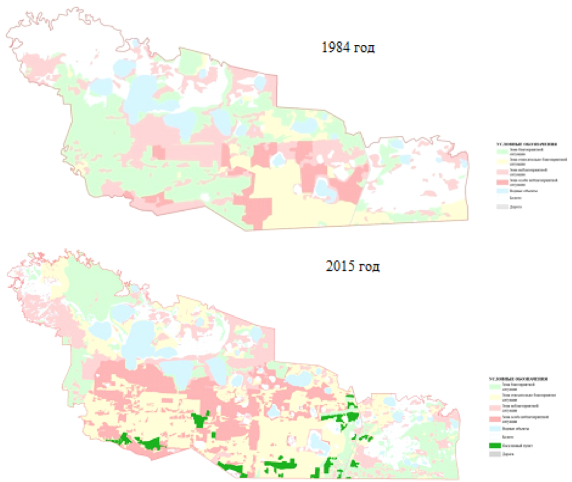
Note. Compiled by the authors
Over thirty years in the area of Tarmanskiy wetland massif unfavorable for the use of the area has increased by 240 square kilometers.
Economic estimation of damage from soil degradation and land is carried out by the method of Girusova E. V.
The researched territory is located in Tyumen region, where the normative value of land is equal to 177 rubles/ha, as the area belongs to the West Siberian economic district, therefore, the coefficient of ecological situation and ecological value of a territory equals to 1.2.
On the area of Tarmanskiy wetland massif 7539,6 hectares of agricultural land prone to waterlogging, of which 5 719,0 hectares – hayfields, 958,7 hectares is arable land, 834,9 hectares area occupied by perennial crops.
Based on the data and the calculations the investigated area is the damage to 1 602 048,2 rubles in terms of 1 ha of damage from waterlogging amounted to 212,5 rubles.
The most important form of organization of the use of State land Fund is the distribution of lands by categories. It is based on the zoning and determination of dominant factors of the productive capacity of the land. Each land area refers to one of the categories, thereby defining objectives, tasks and legal regime of its economic use.
On the basis of the conducted researches it is revealed that the public cadastral map contains a number of errors, the area where developing construction subjects to overgrowing and swamping. In connection with the situation in the land use part of Tarmanskiy wetland massif it is necessary to improve the cadastre and urban planning documents in terms of land distribution by categories.
The map of the distribution of the land Fund of object categories was developed as a project development phase of Tarmanskiy wetland massif, based on the results of research on quality of land (table 2).
Table 2
The ratio of areas in categories of land object of research
Category of land |
Actual area, hectares |
Project area, hectares |
Lands of settlements |
2 013,6 |
2 013,6 |
Agricultural land: |
14 557,3 |
19 432,2 |
Grassland |
14 203,4 |
16 889,0 |
Arable land |
311,0 |
2 500,3 |
Agricultural enterprises |
42,9 |
42,9 |
Land of water fund: |
14 068,0 |
25 995,8 |
Wetlands |
8 509,9 |
20 400,0 |
Lakes |
5 588,1 |
5 595,8 |
Land of forest fund: |
36 255,7 |
19 448,8 |
Forest |
17 889,8 |
11 953,5 |
Shrubs |
18 365,9 |
7 495,3 |
Reserve lands |
1213,3 |
1213,3 |
Total |
68 103,7 |
68 103,7 |
Note. Compiled by the authors
After analyzing the table, we can say that in consequence of the elimination of the process of revegetation in agricultural use, you can enter 4 874,9 hectares, of which 2 685,6 hectares of grassland, 2 189,3 hectares of arable land, thus the area of forest lands will be reduced by 16 776,9 hectares, including the area occupied by forest will decrease by 5 936,3, shrubs for 10 870,6 hectares. As a result of elimination of the process of eutrophication, the area of lands of water Fund will increase by 11 927,8 hectares. So the area of wetlands in Troubleshooting process of overgrowing is more by 11 890,1 hectares, we can say that this area is suitable for the performance of reclamation activities and commissioning.
As a result of monitoring of reclaimed lands in Tyumen region established:
1. Conducted monitoring and evaluation of the actual state of Tarmanskiy wetland massif showed that over the 30 years of the investigated area is of the positive development of waterlogging low degree of 210 square kilometers and the development of new degradation processes: weak and strong degree of zakustarivanie (shifs from grassland to shrub) – area of 183 square kilometers and afforistation – 179 square kilometers.
2. Forecast of development of the degradation processes showed that without the implementation of prevention in the study area by 2025, the area of overgrowth will increase to 380 square kilometers, waterlogging up to 290 km2.
3. For the assessment of favorability of the territory during the 30 years unfavorable territory for the use of land – has increased by 101 km2 (unfavourable and very unfavourable zone).
4. For the improved use of reclaimed land and reducing degradation processes of Tarmanskiy wetland massif of Tyumen region it is necessary:
the reconstruction of drainage channels;
the improvement of information provision to potential owners of land plots on reclaimed areas;
the application of rational distribution of lands for effective land administration;
the input in agricultural production on suitable areas.
Damdin O.S. (2012). Ponyatia, zadachi I vidi monitoring, “Molodoi uchenii” [Concept, objectives and types of monitoring, the "Young scientist"], №1, pp. 165-166.
Girusov E.V. (2003). Ekologia I Economika prirodopolzovania [Ecology and Economics of nature management], Moscow, YUNITI-DANA, Unity, 519 p.
Izrael Y.A. (1984). Ecologiya I control sostoyaniya prirodnoi sredi [Ecology and control of natural environment]. Moscow: Gidrometeoizdat, 560 p.
Komissarov A.V. (2011). Monitoring melioriruemih zemel v Respublike Bashkortostan, “Zemleustroistvo, kadastr I monitoing zemel [Monitoring of reclaimed land in the Republic of Bashkortostan, "Land management, cadastre and land monitoring"]. No. 10, pp. 56-61.
Lesnoi kodeks Russian Federation (2016): Federalnii zakon [Forest code of the Russian Federation: the Federal law]. Moscow, Normateca,.79 p .
O meliorasii zemel (2016): Federalnii zakon [On land reclamation : the Federal law]. Moscow, Normateca, 12 p.
Pashnina E.A., Simakova V.T. (2017). Analis ispolzovania melioriruemih zemel Tarmanskiy bolotnogo massiva Tyumen region. [Analysis of the use of reclaimed land Tamanskiy bog Tyumen region]. In the book: Current issues of science and economy: new challenges and solutions a Collection of materials LI International student scientific-practical conference, pp. 116-119.
Shchedrin V. N., Balakay T. G. (2010). Land reclamation is the basis of Russia APC substainable development. Bulletin of agricultural science of the Don", No. 3., pp. 98-106.
Simakova T. V., Podkovirova M. A., Oleinik A. M. (2015). Formirovanie territorii usoichivogo razvitiya: metodika I paktika zemleustroistva I grdostroitelstva / Agroprodovolstvennaya politika Russia [The formation of sustainable development: methods and practice of land management and urban planning / agri-food policy in Russia]. No. 5 (17), pp. 24-27.
Simakova T.V., Skipin L.N. (2015). Sostoyanie zemelnih resersov na territorii federalnogo poligona gosudarstvennogomonitoringa zemel “Nizhnetavdinskiy” Tyumen region [The state of land resources on the territory of the polygon of Federal state land monitoring "'Nizhnetavdinskiy" Tyumen region]. Vestnik of Krasnoyarsk state agrarian University, № 8, pp. 33-37.
Starovoitova E.S., Simakova T.V. (2017). Organizasiya ispolzovaniya zemel selskohozyaistvennogo naznacheniya [Organization of use of agricultural land of Tyumen region]. In the book: Current issues of science and economy: new challenges and solutions a Collection of materials LI International student scientific-practical conference, pp. 141-143.
Telitsin V. L. (2002). Bolota Vostochnogo Zauralia: Geoekologicheskie osnovi optimizasii prirodopolzovania [Wetlands of East of the Urals: geography and basics of nature management optimization]. Novosibirsk, SB RAS., 95 p.
Varlamov A.A. (2009). Teoriya I metodi vedeniya Gosudarstvennogo monitoinga zemel kak informsionnoi osnovi gosudarstvennogo kadastra nedvizhimosti [Theory and methods of conducting the State monitoring of lands as the information basis of the state cadastre of real estate]. Moscow, MSHA, 323 p.
Vodnii kodeks Russian Federation (2016): Federalnii zakon [Water code of the Russian Federation: Federal law]. Moscow, Prospekt, 48 p.
Zemelnii kodeks Russian Federation (2017): Federalnii zakon [Land code of the Russian Federation: the Federal law]. Moscow, Eksmo-Press, 160 p.
1. Northern Trans-Ural Agricultural University, Republiki Street, 7, Tyumen, Russia 625003. Email: simakova.tamara@mail.ru
2. Tyumen Industrial University, Volodarskogo Street, 38, Tyumen, Russia 625000
3. Northern Trans-Ural Agricultural University, Republiki Street, 7, Tyumen, Russia 625003
4. Northern Trans-Ural Agricultural University, Republiki Street, 7, Tyumen, Russia 625003
5. Northern Trans-Ural Agricultural University, Republiki Street, 7, Tyumen, Russia 625003
6. Northern Trans-Ural Agricultural University, Republiki Street, 7, Tyumen, Russia 625003
7. Northern Trans-Ural Agricultural University, Republiki Street, 7, Tyumen, Russia 625003