![]() ISSN 0798 1015
ISSN 0798 1015

![]() ISSN 0798 1015
ISSN 0798 1015
Vol. 38 (Nº 33) Año 2017. Pág. 34
Gulsara KAMELKHAN 1; Tair Daythanovich JULAMANOV 2; Kurmangul Toletaevna ABAYEVA 3; Dastan Temiralievich JANTELIYEV 4
Received: 05/06/2017 • Approved: 15/06/2017
3. Implementing Precise Farming as a Tool of Rational Use of Agricultural Lands
4. Perspectives of Developing GIS for Rational Use of Agricultural Lands
ABSTRACT: Searching for tools and solutions that allow providing stable land use and complying with its multifaceted needs, agricultural producers use geographic informational systems (GIS) more and more often. The goal of this article is to define basic areas of using GIS to improve the efficiency of using land resources. The conducted research of the state of agricultural lands in the Enbekshikazakhskiy Area shows that agricultural farmlands are within the zone of risky farming and not all land resources are used purposefully. The “precision farming” technology can become one of the approaches that can decrease the degree of indefiniteness and dependence on the external environment of agricultural enterprises of the area. The implementation of precise farming at agricultural enterprises of the Enbekshikazakhskiy Area supposes the need to implement modern geographic information systems to manage large volumes of geocoded spatial data obtained from various sources. The implementation of GIS allows improving the efficiency of management of agricultural enterprises, making swift and professional management decisions, and producing taking into account the terrain and all other peculiarities of territories. |
RESUMEN: En busca de herramientas y soluciones que permitan el uso estable de la tierra y el cumplimiento de sus múltiples necesidades, los productores agrícolas utilizan cada vez más sistemas geográficos informativos (SIG). El objetivo de este artículo es definir áreas básicas de uso de SIG para mejorar la eficiencia del uso de los recursos de la tierra. La investigación llevada a cabo del estado de las tierras agrícolas en el área de Enbekshikazakhskiy demuestra que las tierras agrícolas agrícolas están dentro de la zona de la agricultura de riesgo y no todos los recursos de la tierra se utilizan deliberadamente. La tecnología de "agricultura de precisión" puede convertirse en uno de los enfoques que pueden disminuir el grado de indefinición y dependencia del entorno externo de las empresas agrícolas del área. La aplicación de la agricultura precisa en las empresas agrícolas de la zona de Enbekshikazakhskiy supone la necesidad de implementar modernos sistemas de información geográfica para gestionar grandes volúmenes de datos espaciales geocodificados obtenidos de diversas fuentes. La implementación del SIG permite mejorar la eficiencia de la gestión de las empresas agrícolas, tomar decisiones de gestión rápidas y profesionales y producir teniendo en cuenta el terreno y todas las demás peculiaridades de los territorios. |

One of the major problems of the economic growth of the Republic of Kazakhstan territories is the provision of stable agricultural land use. For the years of independence the Kazakh lands use has considerably changed. Thus, since 1991 to 2016 115,540.4 thous. ha of lands had been withdrawn from agriculture, and the structure of cultivated areas changed.
In many regions and subjects of the Republic Kazakhstan the fertility of topsoil decreased, farmlands degraded and polluted. Since the land is the main source of raw materials for the processing industry and the main condition of ensuring food safety and welfare of the society, problems related to increasing the value of land resources and rational use are still urgent (Моskalenko 2015).
In order to efficiently manage the land fund, it is necessary to have reliable, swift and true information about the state of land resources. Due to this, Kazakh regions activated work on forming informational resources about agricultural lands and their use.
The information management of land resources is provided due to quick development of technologies of remote sensing, creating modern sensors, and real-time monitoring systems, more powerful and smaller computer equipment, and mobile devices; development of means of communication and constant expanding of opportunities and convenience of using geographic information systems and applications based on them (Gokhman 2016a). The main resource and asset in agriculture is land, and the whole activity here has a spatial nature, and is directly related to geography. That is why GIS have become an irreplaceable platform to unite and analyze large volumes of data of various types and formats, integration and close interrelation with many systems of the enterprise level. The ability to quickly analyze these flows of data and their visual cartographic representation causes the emergency of many new projects and opportunities for users from the agricultural or associated areas.
The use of geospatial technologies opens new opportunities for agriculture in such areas as sensing (supplying data and/or equipment), computer control and planning routes, office applications based on geospatial data for working with soils maps, remote sensing of images, monitoring yield and optimization of crops growth, etc. (Farming the Future. GIS for Agriculture, 2013).
The main goal of this research is to reveal promising areas to improve the efficiency of land use by applying geospatial technologies in agricultural production. In order to achieve the goal set in the research, a number of tasks are to be solved:
The object of estimation was agricultural lands (without classifying into land owners and users) and reserve lands as a basic reserve of the land-resourceful potential of agricultural production in the Enbekshikazakhskiy Area of the Almaty Region.
The system approach was accepted as the main methodological method. It takes into account almost all aspects of the problem. Besides, the author used statistical, abstract and logical, and historical methods. Materials for this research included enactments, works of Kazakh and foreign experts in the area of land use, and official reports according to the data of official monitoring of agricultural lands.
One of the methods of estimating agricultural lands on the territory of the Enbekshikazakhskiy Area of the Almaty Region is local monitoring. It is carried out to provide state bodies with true information about agricultural lands on the territory of the Enbekshikazakhskiy Area of the Almaty Region, their quantitative and qualitative state, making quick decision on involving unused areas in the agricultural turnover, and revealing indecent land users. For this purpose, local monitoring of lands is carried out (Pashuta and Solodovnikova 2015).
When monitoring lands and making reports about lands and classifying them according to forms of ownership, farms, and users, the main sources of information include land use documentation, data of the State Cadaster of Real Estate and the Unified State Register of Rights, orders and decrees of the area akim (head of the local executive authority) that cause changes in the land fund of the area, information of akims of rural districts, and data provided by large agricultural enterprises and organizations (Byshov, Byshov, Bachurin, Oleynik, and Yakunin 2013).
In order to obtain information about the state of land fund, the results of remote sensing, land surveys, and reports about lands inventories, and fund materials (maps, cartograms, tables, schemes, etc.) are used.
The indicators of monitoring the lands use include:
Land resources on the territory of the Enbekshikazakhskiy Area of the Almaty Region are accounted by the Department of Property and Land Relations by using the automated system “DPLR” AWP (automated workplace of the employee of the Department of Property and Land Relations).
Now land resources are accounted by applying the automated informational system of the state land cadaster (AIS of the SLC). The purpose of this system is to automate the process of recording the land cadaster. Therewith, its main task is to collect and form data about the land and its users, to update the information and provide state bodies, enterprises, organizations, and population in interest with the data. AIS of the SLC allows carrying out the interrelation with system-forming bases of the Digital Government, akims, and bodies of state management of all levels.
The initial data are formed in regional centers of AIS of the SLC. Then they are integrated on the level of the region, and this information is processed on the level of the Republican Center. After that data of AIS of the SLC can be used by legal entities and individuals in interest (Sirenko, N. D.).
The Enbekshikazakhskiy Area is an administrative unit in the south of the Almaty Region in Kazakhstan. The area includes 25 rural districts and 1 town under regional jurisdiction (Yesik). The administrative center is the town of Yesik. As on February 1, 2015 its population was 288,451 persons.
The territory of the area is 830,703 ha including 265,016 ha of peasant farms, 72,679.0 ha of non-state agricultural legal entities, 96,716.0 ha of settlements, 10,200.9 ha of lands belonging to industries, transport and communication, 81,645.0 ha of specially protected natural territories, 82,980.0 ha of the forest fund, and 3.133.9 ha of the water fund.
The total area of farmlands is 382,895 ha. Figure 1 shows the structure of farmlands of the Enbekshikazakhskiy Area.
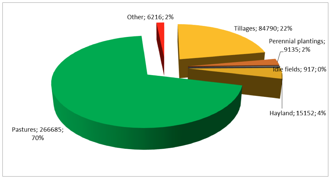
Figure 1. Structure of Farmlands of the Enbekshikazakhskiy Area of the Almaty Region in 2015
In the area there are 120 agricultural organizations, including 1 state enterprise, 76 business partnerships, 22 production cooperatives, and 2 public companies. The main type of activity of the majority of agricultural enterprises in the Enbekshikazakhskiy Area is the growing of cereals and grain legumes, including seed industry.
In 2016 the total cultivated area was 84,554 ha, including cereals – 34,406 ha, oil crops – 13,048 ha, including sunflower – 2,875 ha, soybean – 9,840 ha, and safflower – 9,840 ha. The areas are the following: potatoes - 5,751 ha, vegetables – 9,332 ha, gourds – 430 ha, forage crops – 21,587 ha, and fruits and berries – 4,601 ha. Moisture preserving technologies are applied on the area of 8,600 ha, which makes up 10.2% of the total cultivated lands. Water preserving technologies are used on the area of 3,754 ha.
Farms specialization is based on the comprehensive use of resources from several natural zones. The following zones are defined on the area territory in terms of nature use:
Lands of the Enbekshikazakhskiy Area were estimated by defining the cadaster (appraised) value of farmlands, using basic rates of the payment (standard) that characterize the average value of one hectare of farmlands by their types, soils types and sub-types approved by Order of the Government of the Republic of Kazakhstan No. 890 dated September 2, 2003 and evaluation factors to them that characterize peculiarities of certain farmland massifs defined by Article 11 of the Land Code of the Republic of Kazakhstan (Land Code of the Republic of Kazakhstan, 2003).
The total cadaster (appraised) value of the land in the Enbekshikazakhskiy Area was 1,716.0 bln. tenge, including agricultural lands – 1,333.3 bln. tenge, reserve lands – 382.7 bln. tenge. Table 1 shows the cadaster value of lands by types of farmlands.
Table 1. Cadaster (Appraised) Value of Agricultural Lands
of the Enbekshikazakhskiy Area by Types of Lands
Types of lands |
Cadaster value, tenge |
Ratio in the total appraised value, % |
Not-irrigated tilled area |
818.8 bln. tenge |
47.7% |
Irrigated tilled area |
131.0 bln. tenge |
7.7% |
Perennial plantings – kitchen gardens |
8.5 bln. tenge |
0.5% |
Tillage |
97.7 bln. tenge |
5.7% |
Haylands |
43.1 bln. tenge |
2.5% |
Pastures |
581.9 bln. tenge |
33.9% |
Other lands |
35.0 bln. tenge |
2.0% |
In total |
1,716.0 bln. tenge |
100.0% |
In the structure of cadaster (appraised) value of agricultural lands, the basic ratio – 47.7% - is made up by uncultivated tillage, and tillage makes up 33.9%.
The average value of one hectare of farmland in the area is 8.5 thous. tenge, as differentiated by types of farmlands from 36-97 thous. tenge (uncultivated tillage, cultivated tillage) to 2-4 thous. tenge (other lands, pastures).
In order to implement official instruction No. 01-7.4, clause 12 of the extended session of the Government with the participation of the President of the Republic of Kazakhstan dated April 17, 2011 about inventorying lands and improving soils fertility, the Department of Property and Land Relations of the Enbekshikazakhskiy Area performs work on revealing unused agricultural lands in districts (towns) of the area. According to the results of the inventory carried out by the local executive bodies (towns), programs for 2012-2015 on involving unused lands in the agricultural turnover were approved.
When comparing the accounted data with the obtained data, the discrepancies for lands with the data as on 01.11.1990 were 168.175 thous. ha, including tillage 96.4 thous. ha, including cultivated area 26.4, perennial plantings – 0.49 thous. ha, haylands 36.06 thous. ha, pastures 51.885 thous. ha, the inventory showed 1,284.41 thous. ha, including tillage 847.90 thous. ha, including cultivated area 350.60 ha, perennial plantings 9.135 ha, haylands 151.52 thous. ha, including improved land 77.580 thous. ha, pastures 266.685 ha, including improved land 178.758 thous. ha, waterlogged land 55.828 thous. ha.
The 2015 audit of agricultural lands revealed 915.5 ha of unused lands, which is 267.1 ha less than that of the previous year. The ratio of undemanded lands in the depreciation value of the land fund is 22.3% from the total appraised value. The main reasons of non-using agricultural lands include the lack of cattle, low efficiency of tillage areas, and losses due to the source of irrigation.
At small areas no crop rotation is complied with, monocrops are used, follows are not used on boharic tillage. Reasons of low farming culture include the lack of the material and technical base, specialized equipment, sales markets, agro-chemical service (fertilizers are used violently, without taking into account the actual content of nutritional elements in the soil and needs of plants), and the lack of qualified agronomic assistance to small peasants’ farms (Nikolaychuk 2015).
The majority of farmlands of the Enbekshikazakhskiy Area are in the zone of risky farming, the tillage extending is limited by irrigational networks. At the same time, one of the urgent state tasks is to increase local agricultural production, and improve profitability of agricultural production. It can be implemented by using two basic strategies: unused land resources must be brought to the agricultural turnover, and the existing cultivated lands must be rationally and intensively used by applying the relevant management.
In both cases it is important to know characteristics and allocation of soils in the area. Thus, there is an urgent need in creating the system that can provide accurate, useful and timely information about land and water resources for directive bodies. Such system is a required condition for planning the development of agricultural production, efficient use of land resources and implementation of the area development programs.
One of the main difficulties faced by agricultural producers of the Enbekshikazakhskiy Area is a high level of dependence on external factors (natural and economic, environmental). It causes serious risks and indefiniteness.
Taking a decision about the term of various field works, agricultural organizations act at random, combining elements of the common situation – weather conditions, previous observations and their experience. And even if the estimation of the initial factors is correct, results are unpredictable. It is possible to judge about the correctness of the taken decision only after gathering yield at the end of the season. However, consequences of decisions taken in the agricultural production incorrectly are often serious.
Precise farming is one of the approaches that can help to change the situation and decrease risks of farming due to measurements precisely related to the location and farmers’ taking into account the spatial inhomogeneity of the content of soil, terrain, illumination and other characteristics that exist even within one field or fields located near each other (Trufliak 2016).
Precise farming (coordinated farming, adaptively landscape farming, precision farming) is a scientific concept and area in the agrarian production based on the ideas about the inhomogeneity of soil fertility within one field. Taking it into account allows maximizing the profit by differentiated use of fertilizers and crop-protection agents.
According to specialists, the technology of precise farming can acutely decrease the ecological footprint from food production. The consumption of energy (oil) decreases by 10-15%, and the use of resources (for example, crop-protection agents, fertilizers, and water) decrease by 10-20% subject to the same level of production, or, in other words, the efficiency of labor increases per kilogram of fertilizers, liter of oil, liter of water or man hour.
Consequently, the government of the Republic of Kazakhstan and local bodies must stimulate the implementation of the precise farming technology because it will contribute not only to improving the efficiency of using land resources, but also solving ecological problems.
Precise farming assumes that it is reasonable to divide the field into separate zones and apply various agro-technical procedures (seeding standards, fertilizing, etc.) at each of these zones. It must cause an increase in the general yield and simultaneous saving of the seeding materials, fertilizers, combustive and lubricant materials, etc.
As N. Rasher notes, precise farming depends on three basic factors (Rasher, N. D.):
Precise farming requires detailed information about the field. The key information is collected by analyzing soil samples and is used to define precise amount of nutritional substances or seeds required for this area of the field, differentiated standards of watering, using crop-protection agents, and taking other measures in the appropriate place at the appropriate time (Gohman 2016b). The more precisely the amount is defined, the higher the yield and the less wastes are, and consequently, the higher the profitability of the organization is. The information is collected not only during active vegetation but also during the whole year.
Precise farming requires obtaining, managing, analyzing and outputing large volumes of spatial and time data that are not provided on paper. At the same time the informational limitation of such bearer does not allow complete automating functions of the authorities related to using cartographic materials. Due to it, as a rule, provision of state services is delayed.
The implementation of precise farming at agricultural enterprises of the Enbekshikazakhskiy Area supposes the need to create the integrating basis for accumulating, storing, processing, modeling, interpreting, analyzing, and displaying all collected information that characterizes seeding, tillage and the whole agricultural terrain. Technologies of GIS are such a tool.
In European countries and in the USA the majority of farmers use GIS for precise farming, and they have considerably succeeded in their goals (Deepak and Amin 2003). The majority of users and researchers confirm that GIS is a key for the agriculture to become fully successful when fully and correctly performing its work.
GIS is a software system developed specially for managing great volumes of geocoded spatial data obtained from various sources (Deepak and Amin 2003).
GIS opportunities are related to the fact that they can accept the incoming data, serve as a center of data exchange, store, retrieve, analyze, superpose and display this data based on the user’s requirements, and create both table and thematic maps that show the spatial allocation of data.
The use of precise farming technology starts with making digital maps with the aid of GIS and satellite images that show the terrain differentiation of farming conditions (Pleskachev 2015).
To make management decisions in agriculture, and particularly, in crop farming, it is necessary to know parameters of the field and be able to use this information. In the majority of cases paper maps used by farmers do not show the real situation. New technologies of collecting field data for making maps, and new methods of work with maps by using PCs show objects more accurately: areas and contours of fields, location of roads, etc.
One of perspective means of cartography and obtaining information for creating digital maps is the Outer-Space System of Earth Remote Sensing. The Republic of Kazakhstan has its own Outer-Space System of Earth Remote Sensing (OSS ERS), and the land complex of managing satellites and land target complex for accepting, processing and distributing ERS by end users. Thereby the opportunity to obtain space images on any territory of the planet at any part of the day was obtained (Tulepov 2016).
Besides, the land infrastructure of the high precision satellite navigation system (HPSNS) of the Republic of Kazakhstan was put into operation. This system allows defining coordinates of objects with the accuracy of up to 1 cm on the whole territory of Kazakhstan by using GPS and GLONASS global navigation satellite systems. OSS ERS and HPSNS are the key elements for the further development of GIS technologies in Kazakhstan.
Another way to create a digital map of fields is the field method. Using GPS receiving sets, a field computer and special software, they go around boundaries of every field and account all “not farmlands” (ravines, bogs, bushes, power transmission lines, hydrants of irrigation systems, forest belts, etc.), and make digital maps with the centimeter accuracy.
The creation of an own system to monitor the state of seeding for working with the full set of corporate data about fields can be an efficient tool of improving the efficiency of using land resources.
Now farms keep the accounting information about fields by agricultural producers of the Enbekshikazakhskiy Area in such systems as 1C, SAP, and Excel. However, such data do not include additional information, for example, weather data or level of seeding vegetation during the whole season that are an important set of parameters for agriculturists and other specialists.
It is entirely obvious that the existing systems of accounting must be extended by creating a system of monitoring of the seeding state that later can be supplemented with the block of yield forecast. Ready-to-use components that are parts of the ArcGIS industrial geographic information platform and are successfully used around the world allow creating an efficient system.
ArcGIS is a general platform for the integration of all accumulated information and coordination of actions based on it. It provides the interrelation with many business-systems: enterprises resources management (ERM), computer aided dispatching and coordination of works (CAD), enterprise assets management (EAM), records management system (RMS), clients relations management (CRM), and allows obtaining additional profits from showing various variables and parameters on the map (Nagorniuk 2016).
The incoming data for the system include table materials about fields from 1C, SAP or Excel that are linked to geometrical boundaries displayed on the digital map. At this stage the organization obtains the informational reference system with the opportunity of retrospective analysis of its lands use.
Then meteorological data about humidity and temperature in certain places of the network are downloaded and interpolated in every field by using ArcGIS. Meteorological data are stored in the corporate base for retrospective analysis.
ArcGIS mobile applications can considerably assist in optimizing the process of collecting information about the state of fields and crops. In the ArcGIS products line there are quite many applications aiming at solving certain tasks. For example, Workforce for ArcGIS, Collector for ArcGIS, Survey123 applications allow adjusting the process of collecting data by using mobile devices directly at the place of works. All these applications are free for ArcGIS users and operate together with ArcGIS Online or Portal for ArcGIS (Naymushina 2016).
The conducted research studied the state, use and estimation of lands according to the main types of farmlands of the Enbekshikazakhskiy Area of the Almaty Region.
The conducted research shows that GIS contribute to rational management of land resources, allow creating the geodata base, coordinate actions and allow developing the strategy, inventorying, and monitoring the state of land cadasters of various levels. The use of GIS enables agricultural producers to decrease expenses, increase yield, make the detailed analysis, and forecast the results of their activity.
Byshov N.V., Byshov D.N., Bachurin A.N., Oleynik D.O., Yakunin Yu.V. (2013). Geoinformatsionnie sistemy v selskom hozyaystve [Geo-Informing Systems in Agriculture]. Ryazan: FGBOU VPO RGATU, pp. 169.
Deepak T. J. and Amin M. S. M. (2003). Dominance of Geographic Information System in Developing a Database for Precision Farming. J. Hum. Ecol., 14(5), 329-335
Farming the Future. GIS for Agriculture, (Vol 2). Esri. (2013). Retrieved April 29, 2017, from http://www.esri.com/library/ebooks/farming-the-future.pdf
Gohman V. (2016a). GIS dlya selskogo hozyaystva [GIS for Agriculture]. ArcReview, 3. Retrieved April 29, 2017, from https://www.esri-cis.ru/news/arcreview/detail.php?ID=24053&SECTION_ID=1095
Gohman V.V. (2016b). Tochnoe zemledelie i GIS [Precision Agriculture and GIS]. ArcReview, 3(78). Retrieved April 29, 2017, from https://www.dataplus.ru/news/arcreview/detail.php?ID=24059&SECTION_ID=1095
Moskalenko A. (2015). Principles and Problems of Agricultural Land Rational Use. Economic Annals-XXI, 5-6, 57-59
Nagornyuk K. E. (2016). Sistema monitoringa sostoyaniya posevov – instrument dlya agronoma, investora, strahovschika [System of Monitoring State of Sowing – a Tool for Agronomist, Investor, and Insurer]. ArcReview. 3 (78). Retrieved April 29, 2017, from https://www.dataplus.ru/news/arcreview/detail.php?ID=24055&SECTION_ID=1095
Naymushina A.M. (2016). Mobilnye prilozheniya ArcGIS dlya sbora dannyh [Mobile Applications ArcGIS for Collecting Data]. ArcReview, 3(78). Retrieved April 29, 2017, from https://www.dataplus.ru/news/arcreview/detail.php?ID=24062&SECTION_ID=1095
Nikolaychuk A. A. (2015). Monitoring zemel. Analiz ispolzovaniya zemelnyh resursov v Respublike Kazahstan. Prioritetnye napravleniya razvitiya nauki i obrazovaniya [Lands Monitoring. Analysis of Using Land Resources in the Republic of Kazakhstan. Top-Priority Areas of the Science and Education Development]: Materials of the V International Research and Practical Conference in Cheboksaryi, June 12, 2015. TsNS “Interaktiv plyus”, 2 (5), 421–422.
Pashuta A.O. i Solodovnikova M.P. (2015). Monitoring zemel selskohozyaystvennogo naznacheniya kak metod gosudarstvennogo upravleniya zemelnymi resursami [Monitoring Agricultural Lands as a Method of State Management of Land Resources]. Bulletin of the Voronezh State Agrarian University, 3 (46), 245-252.
Pleskachev Yu. N. (2015). Vnedrenie sistem tochnogo zemledeliya v proizvodstvo [Implementing Systems of Precision Agriculture in production]. Retrieved April 29, 2017, from http://www.rynok-apk.ru/articles/plants/sistemy-tochnogo-zemledeliya
Rasher M. (N. D.). The Use of GPS and Mobile Mapping for Decision-Based Precision Agriculture. Retrieved April 29, 2017, from http://www.gisdevelopment.net/application/agriculture/overview/agrio0011.htm
Sirenko G.V. (N. D.). Avtomatizatsiya sistemyi zemelnogo kadastra Respubliki Kazahstan. Mezhdunarodnaya nauchno-tehnicheskaya internet-konferentsiya. Retrieved April 29, 2017, from http://kadastr.org/conf/2013/pub/kadastr/ais-gzk-kazahstan.html
Truflyak E. V. (2016). Osnovnye elementy sistemy tochnogo zemledeliya [Basic Elements of the Precision Agriculture System]. Krasnodar: KubGAU, pp. 39
Tulepov D. (2016). Kosmicheskiy vzglyad na zemnye zaboti [Space View at Land Cares]. Evening Astana, 153. Retrieved April 29, 2017, from http://kazatu.kz/assets/i/smi/smi_20161231.pdf
Zemelniy kodeks RK [Land Code of the Republic of Kazakstan]. (2003). President of the Republic of Kazakhstan N. NAZARBAEV. Astana
1. Kazakh National Agrarian University, 050010, Kazakhstan, Almaty, Abai Street, 8
2. Kazakh National Agrarian University, 050010, Kazakhstan, Almaty, Abai Street, 8
3. Kazakh National Agrarian University, 050010, Kazakhstan, Almaty, Abai Street, 8
4. Kazakh National Agrarian University, 050010, Kazakhstan, Almaty, Abai Street, 8